Best Management Practices for Salmonid Stewardship on Woodlands
Best Management Practices for Salmonid Stewardship on Woodlands
Originally published November, 2015
Guest Post by MCFC Board Member Katie McLean
The content in this blog post is adapted from an introductory best management practices guidance document produced by Clean Annapolis River Project.
What is a watershed? A watershed is the entire region from which rainfall and snowmelt drains into a single water body. The high degree of interconnectivity within watersheds means that activities occurring anywhere within its borders can impact ecological conditions. Nova Scotia is divided into 46 primary watersheds.
Native Salmonids in Nova Scotia: Brook Trout and Atlantic Salmon:
Salmonids are a family of fish that includes salmon, trout and char. Salmonids depend on freshwater to spawn, but may spend other parts of their life cycle in salt or freshwater. Native salmonids to Nova Scotia include the Atlantic salmon (Salmo salar) and brook trout (Salvelius fontinalis). Other species of salmonids that have been introduced and/or are actively stocked include the brown trout (Salmo trutta), rainbow trout (Onchorynchus mykiss), and lake trout (Salvelinus namaycush).
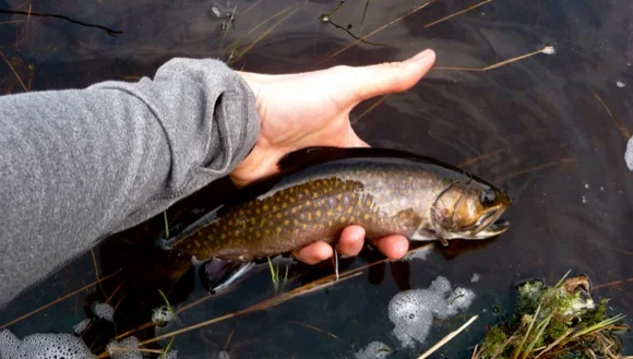
Nova Scotia Brook Trout (photo: Katie McLean)
Salmonids are cold water species, and each individual species has slightly different water temperature preferences. Water temperatures around 10-15˚C are ideal for Nova Scotia’s native salmonids, but they can survive in water up to 20˚C. Temperatures above this point can cause lethal stress.
What does good quality salmonid habitat include?
Salmonids require several habitat types in order to complete key stages in their lifecycles, including breeding, rearing, feeding and overwintering.
Characteristics of a healthy trout stream…
Well oxygenated water (cold water can hold more oxygen than warm water)
Healthy streamside vegetation, providing the shade necessary to keep water temperatures optimum for trout & salmon habitat
Large woody debris to provide cover from predators and shade to help keep water temperatures cool
An assortment of stream bed materials (sand, gravel, cobble)
Meandering stream channel with well defined pools and riffle sections
Undercut banks on the outside bends with sufficient vegetation to prevent erosion and bank failure
Moose River, Annapolis County (Photo: Katie McLean)
How can forestry practices affect salmonid habitat?
Increased sedimentation from management activities or at point sources such as roads
Reduced canopy and the shade provided by vegetation can lead to an increase in water temperatures (thermal pollution) and loss of cold water refuges
Loss of habitat and habitat fragmentation. Improperly designed or installed culverts or water crossings may block fish passage, remove resting pools, or create flow conditions that are too shallow or fast for fish.
Fuel wood harvesting and stream clearing can deplete large woody debris which contributes to habitat complexity
Regulatory Requirements & Special Management Zones
Within the Nova Scotia Forests Act, the Wildlife Habitat and Watercourses Protection Regulations (section 40) outline the legal obligations of forestry operations related to the protection of fish habitat, including the establishment of Special Management Zones on the land adjacent to watercourses. In the case of watercourses that are equal or greater than 0.5 meter average width, a 20 metre wide special management zone is required. The best management practices recommended are intended to compliment or supplement these minimal legal requirements.
Best Management Practices:
Establish and respect filter areas...
Filter areas refer to the vegetated area that borders waterbodies, including the riparian zone and forested habitat. These areas perform critical functions in maintaining water quality, including the filtration of debris and sediment from run-off, and the filtration of nutrients, pesticides or other pollutants that may be present in run-off water, or bound to sediment.
Healthy forested filter area on the Nictaux River (Photo: Clean Annapolis River Project)
Increase width of filter areas when needed in cases such as...
Ephemeral flow areas next to waterbodies. These areas may carry sediment or other materials directly into streams;
Forested wetlands and floodplains. These areas often have weaker, wetter soils, making them prone to developing ruts and producing rapid run-off;
Water diversions that concentrate flow, such as culverts or ditches, which can increase the amount of Flow into filter areas, and could create new channels, reducing the effectiveness of filter areas. Draining structures to help disperse water may also be an option.
Plan for and control water flow...
By understanding how water will move within a harvest area, appropriate measures can be taken to slow down and spread out run-off. By directing small amounts of water into areas of undisturbed forest floor (filter areas), it can be absorbed and filtered.
During pre-harvest planning, compile site information such as the location of wetlands and watercourses, steep slopes and other topographic features, soil conditions, etc. and use this information when planning harvest operations and selecting the locations of operational features such as roads, stream crossings, skids trails, etc. Concentrated water flows tend to form along roads, skid trails, landings and in drainage systems, generating greater force and increasing the ability of water to erode soil and carry sediment. It is most effective to control small volumes of water before they converge and accumulate.
Protect the natural movement of water through wetlands...
One critical function of wetlands is their ability to store water, which is later released into the surrounding ground and watercourses. The installation of logging roads and crossings can affect the movement of water within or through wetlands, which may in turn impact the amount of water that a wetland can store, the degree of flooding that occurs, and the rate at which water is discharged from a wetland.
Minimize and stabilize exposed soils...
Disturbance to areas with exposed mineral soil and the stabilization of exposed mineral soils is essential for reducing/preventing erosion, and is particularly critical in filter areas and riparian zones.
In managed forests, exposed soils on roads, landings and skid trails tend to be the largest contributors of the sediment that ends up in streams. In some situations, planting or seeding of vegetation might be required to stabilize soils. Temporary materials that can be used for stabilization include hay or straw mulch, brush/slash/tops from harvesting, or erosion control blankets. More permanent options include wood chips/wood waste/bark mulch, gravel, riprap, or permanent erosion control blankets.
Fish habitat Enhancement Options:
Digger logs - re-establish the natural meander of the stream, and to create pools and gravel beds for spawning.
Wing deflectors - deflect the flow in the desired direction, protect the bank from the erosive force of the flow and raise the water level by constricting the channel to its ideal width.
Submerged brush shelters and large woody debris - Logs and fallen trees can be anchored into place at strategic locations to perform a variety of tasks: stream bank protection, creation of overhead cover for fish, creation of spawning beds and pools.
Retaining Walls - built against the streambank to support areas of heavy erosion, and can provide opportunity for vegetation to re-establish.
Pool Riffle Re-construction - the use of boulders, logs, or other natural materials to increase habitat complexity.
The Issue of Culverts:
Habitat fragmentation caused by barrier culverts can impede the upstream and downstream movements of fish through a stream system. Insufficient water depths, incorrect sizing, steep slopes and large outflow drops are just a few examples of problems that can characterize a culvert as a barrier. When fish migration is restricted in a stream, it can have significant negative impact on fish populations.
In Nova Scotia, an audit preformed by Fisheries and Oceans Canada (DFO) in 2002 revealed that 58% of culverts assessed in central Nova Scotia contributed to habitat fragmentation due to either excessive slopes or elevated outfall drops. Culvert assessments in the Annapolis watershed conducted by Clean Annapolis River Project have revealed that a majority of culverts create either a partial or full barrier to fish migration (79% of assessed sites).
Perched culvert, blocking access to upstream habitat (Photo: Clean Annapolis River Project)
Culverts are often the most cost effective method for creating a water crossing, making them incredibly prolific on our landscape. When selecting to install a culvert, it is paramount that the established technical guidelines be adhered to and that the hydrological features of a stream (i.e. stream width, depth, slope, streambed material) and the surrounding watershed be taken into consideration during the planning stages of culvert installation in order to minimize the chance of a culvert becoming a barrier. Seasonal changes in average water levels should also be factored in to the planning process, as many of our streams vary significantly throughout the seasons.
When possible, bridges are the preferred option for water crossings in streams with migratory fish species.
Rock weir and fish slide used to restore upstream access at a barrier culvert in Annapolis County, NS (Photo: Clean Annapolis River Project)


